

Proposed changes for Jalisco electoral map
Chapala and Jocotepec would be placed in district two
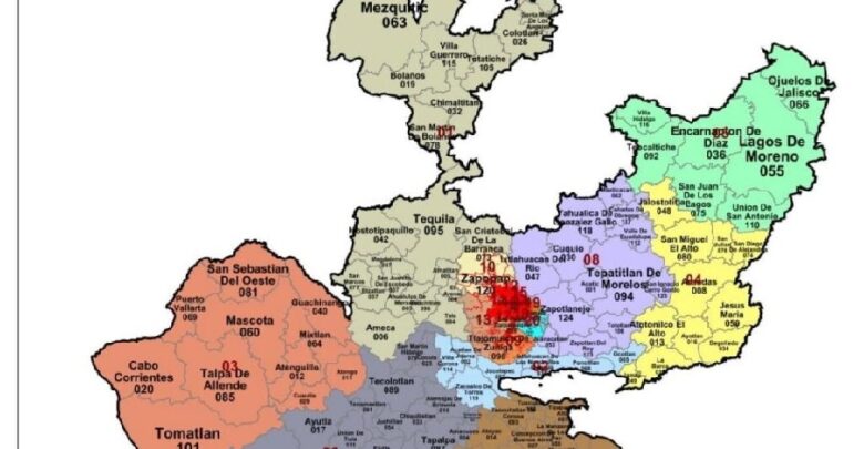
The change is due to the decrease in population in the ZMG and growth in municipalities of Jalisco outside of the ZMG . Photo: Internet.
Editorial Staff.- The new district map proposed by the National Electoral Institute (INE) for the Lake Chapala region for 2022 proposes the division of the municipalities bordering Lake Chapala into electoral districts two, four and eight. The proposal is a result of the decrease of the population in districts of the Metropolitan Zone of Guadalajara (ZMG) and the growth of municipalities such as Ixtlahuacán de los Membrillos. Jalisco will still have 20 state and federal districts.
Chapala would be located in district two along with Jocotepec, Ixtlahuacán de los Membrillos, Poncitlán, Ocotlán, Zacoalco de Torres, Acatlán de Juárez and Villa Corona.
District four would consist of Jamay, La Barca, Degollado, Atotonilco el Alto, Ayotlán, Jesús María, San Diego de Alejandría, San Julián, San Miguel el Alto, Jalostotitlán and Arandas.
District eight will be made up of Tototlán, Zapotlán del Rey, Tepatitlán, Ixtlahuacán del Río, Zapotlanejo, Acatic, Yahualica de González Gallo, Mexticacán, Valle de Guadalupe, San Ignacio Cerro Gordo and Juanacatlán.
The proposal was delivered to the political parties accredited in the Surveillance Commissions and the local Electoral Institutes for their analysis and observations, which will be submitted for the consideration of the General Council of INE.
The project began in 2021 and will conclude in 2023 prior to the 2023-2024 electoral period.
Translated by Elisabeth Shields
Los comentarios están cerrados.


© 2016. Todos los derechos reservados. Semanario de la Ribera de Chapala

